


la Bénisson Dieu

taguette
User
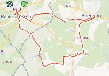

Length
12.4 km

Max alt
345 m

Uphill gradient
179 m
Km-Effort
14.9 km

Min alt
257 m

Downhill gradient
190 m
Boucle
No
Creation date :
2022-04-29 07:35:29.962
Updated on :
2022-04-29 10:15:14.603
2h38
Difficulty : Easy

FREE GPS app for hiking
 SityTrail
IGN / Geographical institutes
SityTrail Plus
The world is yours!
About
Trail Walking of 12.4 km to be discovered at Auvergne-Rhône-Alpes, Loire, La Bénisson-Dieu. This trail is proposed by taguette.
Positioning
Country:
France
Region :
Auvergne-Rhône-Alpes
Department/Province :
Loire
Municipality :
La Bénisson-Dieu
Location:
Unknown
Start:(Dec)
Start:(UTM)
580813 ; 5111305 (31T) N.
Comments